Mullaghruttery


![]()
![]()
![]()
Description
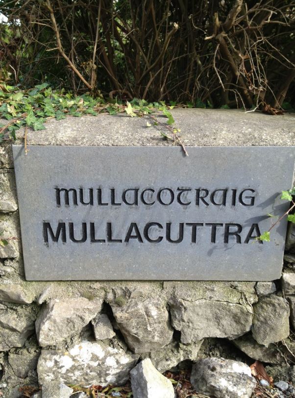
It is told in a story from Irish folklore that the name Mullacuttra originated from Mullach a ‘Chait Rua’ which was a Great Red Cat that guarded a treasure buried in the area in olden times. A feature of the area is the striking stone walls dividing the fields.
Name(s): Mullaghruttery or Mullacuttra townlands.ie/mullaghruttery
Gaeilge: Mullach Otraigh logainm.ie/mullaghruttery
Meaning(s): Hill of the Great Red Cat
Description: Land is arable, suitable for grazing and tillage.
Situated: Mullaghruttery is on the right as you go to Corrandulla. It adjoins Peake.
Sub-dominations: None
Boundaries-townland(s): Gortadooey, Peake and Waterdale (Claregalway) Caraun and Carheeny (Lackagh)
Civil & Church of Ireland Parish: Claregalway – Claregalway Civil Parish (John Grenham)
Barony: Clare – Connacht Baronies
District Electoral Division (DED): Claregalway – Map of Ireland
Poor Law Union (PLU): Galway (Poor Law Valuation) – Poor Law Unions (1851)
County: Galway – galway.ie
Diocese: The Diocese of Galway, Kilmacduagh and Kilfenora – Galway Rural
Province: Connacht(Connaught)
The Down Survey Map
(1650’s)
Search Down Survey Landowners/mullaghruttery
O’Donovan’s field names book 1838
Search Mullaghruttery
Families
: (Pre 1911)
Connell, Glynn, Golding, Herwood, Hogan, Keane, Hughes, Lambert and Lyons
Landlord(s)
James Staunton Lambert
Records
(Claregalway Parish)
Tithe Applotments (c1827)
The names of occupiers and the size of their agricultural holdings, over one acre only, in each townland. To determine the amount that they should pay in tithes to the Church of Ireland. (titheapplotmentbooks.nationalarchives.ie)
Search Claregalway
Roman Catholic Parish Registers
- Baptism (Claregalway 1849-1881): The Catholic Church’s collection of the parish baptismal registry. (registers.nli.ie)
- Marriage (Claregalway 1849-1883): The Catholic Church’s collection of the parish matrimonial registry. (registers.nli.ie)
- Burial (Claregalway 1849-1876): The Catholic Church’s collection of the parish burial registry. (registers.nli.ie)
Griffith Valuation’s
Primary Valuation of Ireland
A survey involving a detailed valuation of every taxable holding of agricultural or built property on the island of Ireland. Completed between 1864-1865 . Date of Publication for Claregalway was 1855. (askaboutireland.ie)
Search Mullaghruttery
General Registry of Office (GRO) Records
- Civil Registery Birth: (1864-1915) The official State records of births in Ireland. (irishgenealogy.ie)
- Civil Registery Marriage: (1864-1940) The official State records of marriage in Ireland (irishgenealogy.ie)
- Civil Registery Death: (1864-1960) The official State records of death in Ireland (irishgenealogy.ie)
Census of Ireland (1821- 1911)
- 1821 vs 1831 (General Parish Population Only)
- 1831 (Summary of Returns for Claregalway Parish Only)
- 1841 (Summary of Returns for Parish Only)
- 1851 (Summary of Returns for Townlands Only)
- 1861 (Summary of Returns for Townlands Only)
- 1871 (Summary of Returns for Townlands Only)
- 1881 (Summary of Returns for Townlands Only)
- 1891 (Summary of Returns for Townlands Only)
- 1901 (Mullaghruttery)
- 1911 (Mullaghruttery)
Research
Index and Transcripts of memorials of deeds, conveyances and wills, 1708-1929
by Registry of Deeds, Dublin
familysearch.org/registryofdeeds/search/
Archaeological Survey of Ireland (ASI)
The Archaeological Survey of Ireland (ASI) is a unit of the National Monuments Service.
No Entries for Mullaghruttery
archaeology.ie/historicenvironment/
More to Follow!
No Comments
Add a comment about this page