Claregalway


![]()
![]()
![]()
Description
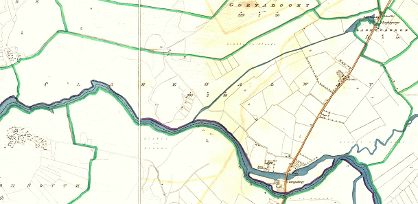
The Claregalway townland stretches from the Claregalway bridge to the Garda barracks and westward along the river as far as Gortcloonmore. The village of Claregalway itself does not lie within this townland. The parish name was taken from this townland possibly because the original church was located on the grounds of the 13th century Franciscan Friary, one of the main landmarks in the area. Claregalway’s present-day graveyard surrounds the ruins of the Friary. A short distance from the Friary stands Claregalway Castle, overlooking the Clare River. The Nine Arches bridge also lies within the Claregalway townland. A new landmark is the SMA House opposite the Friary.
Cloonbiggen is a better known name for part of Claregalway townland. A reference exists in an article about the Friary in 1837 when six acres of land in Cloynbiggan were given to the friars.
There is also a small river, which rises from a spring near Loughgeorge, and it flows through Cloonbiggen into the Clare River. There are some spring wells in this area also. One is known as Tobar Dubh. The land is mainly good but some of it is low lying and liable to flooding in winter.
The origin of the name Claregalway is not clear. Variations used in the past include ‘Baile an Chláir’ meaning ‘Town of the Plank,’ (used for crossing the river) and ‘Town of the Plain.’ Baile Chláir na Gaillimhe is a direct translation of Claregalway and has been in use for the last eighty years.
Name(s): Claregalway, Clar ya dowl townlands.ie/claregalway
Gaeilge: Baile Chláir na Gaillimhe logainm.ie/claregalway
Meaning(s): Town on the plain
Description: Variations used in the past include ‘Baile an Chláir’ meaning ‘Town of the Plank,’ (used for crossing the river) and ‘Town of the Plain.’
Situated: The Claregalway townland stretches from the Claregalway bridge to the Garda barracks and westward along the river as far as Gortcloonmore.
Sub-dominations: Cloonbiggen, Móinín Ríbeach, Léana, Cúinne Cam, Bóithrín Ó Kane and Bóithrín Lachach
Boundaries-townland(s): Cahergowan, Gortacloonmore, Gortadooey, Kiniska, Lecarrowmore, Loughgeorge, Montiagh North and South, Peake, Rooaunmore
Civil & Church of Ireland Parish: Claregalway – Claregalway Civil Parish (John Grenham)
Barony: Clare – Connacht Baronies
District Electoral Division (DED): Claregalway – Map of Ireland
Poor Law Union (PLU): Galway (Poor Law Valuation) – Poor Law Unions (1851)
County: Galway – galway.ie
Diocese: The Diocese of Galway, Kilmacduagh and Kilfenora – Galway Rural
Province: Connacht(Connaught)
The Down Survey Map
(1650’s)
Down Survey Landowners/claregalway
O’Donovan’s field names book 1838
Families
: (Pre 1911)
Allen, Byrne, Casserly, Duggan, Finnerty and Ryan
Landlord(s)
Lord Clanmorris (Bingham)
Records
(Claregalway Parish)
Tithe Applotments (c1827)
The names of occupiers and the size of their agricultural holdings, over one acre only, in each townland. To determine the amount that they should pay in tithes to the Church of Ireland. (titheapplotmentbooks.nationalarchives.ie)
Search Claregalway
Roman Catholic Parish Registers
- Baptism (Claregalway 1849-1881): The Catholic Church’s collection of the parish baptismal registry. (registers.nli.ie)
- Marriage (Claregalway 1849-1883): The Catholic Church’s collection of the parish matrimonial registry. (registers.nli.ie)
- Burial (Claregalway 1849-1876): The Catholic Church’s collection of the parish burial registry. (registers.nli.ie)
Griffith Valuation’s
Primary Valuation of Ireland
A survey involving a detailed valuation of every taxable holding of agricultural or built property on the island of Ireland. Completed between 1864-1865 . Date of Publication for Claregalway was 1855. (askaboutireland.ie)
Search Claregalway
General Registry of Office (GRO) Records
- Civil Registery Birth: (1864-1915) The official State records of births in Ireland. (irishgenealogy.ie)
- Civil Registery Marriage: (1864-1940) The official State records of marriage in Ireland (irishgenealogy.ie)
- Civil Registery Death: (1864-1960) The official State records of death in Ireland (irishgenealogy.ie)
Census of Ireland (1821- 1911)
- 1821 vs 1831 (General Parish Population Only)
- 1831 (Summary of Returns for Claregalway Parish Only)
- 1841 (Summary of Returns for Parish Only)
- 1851 (Summary of Returns for Townlands Only)
- 1861 (Summary of Returns for Townlands Only)
- 1871 (Summary of Returns for Townlands Only)
- 1881 (Summary of Returns for Townlands Only)
- 1891 (Summary of Returns for Townlands Only)
- 1901 (Claregalway) (Barrack Residents)
- 1911 (Claregalway) (Barrack Residents)
Research
Index and Transcripts of memorials of deeds, conveyances and wills, 1708-1929
by Registry of Deeds, Dublin
familysearch.org/registryofdeeds/search/
Archaeological Survey of Ireland (ASI)
The Archaeological Survey of Ireland (ASI) is a unit of the National Monuments Service.
- Castle – tower house – GA070-036
- Bawn – GA070-036001
- Settlement – medieval – GA070-109
- Graveyard – GA070-035002
- Water mill – GA070-035027
- Religious house – Franciscan friars – GA070-035001
- Loughgeorge/Laghtgeorge Garda Station – Reg. No. 30407010
archaeology.ie/historicenvironment/
More to Follow!
No Comments
Add a comment about this page