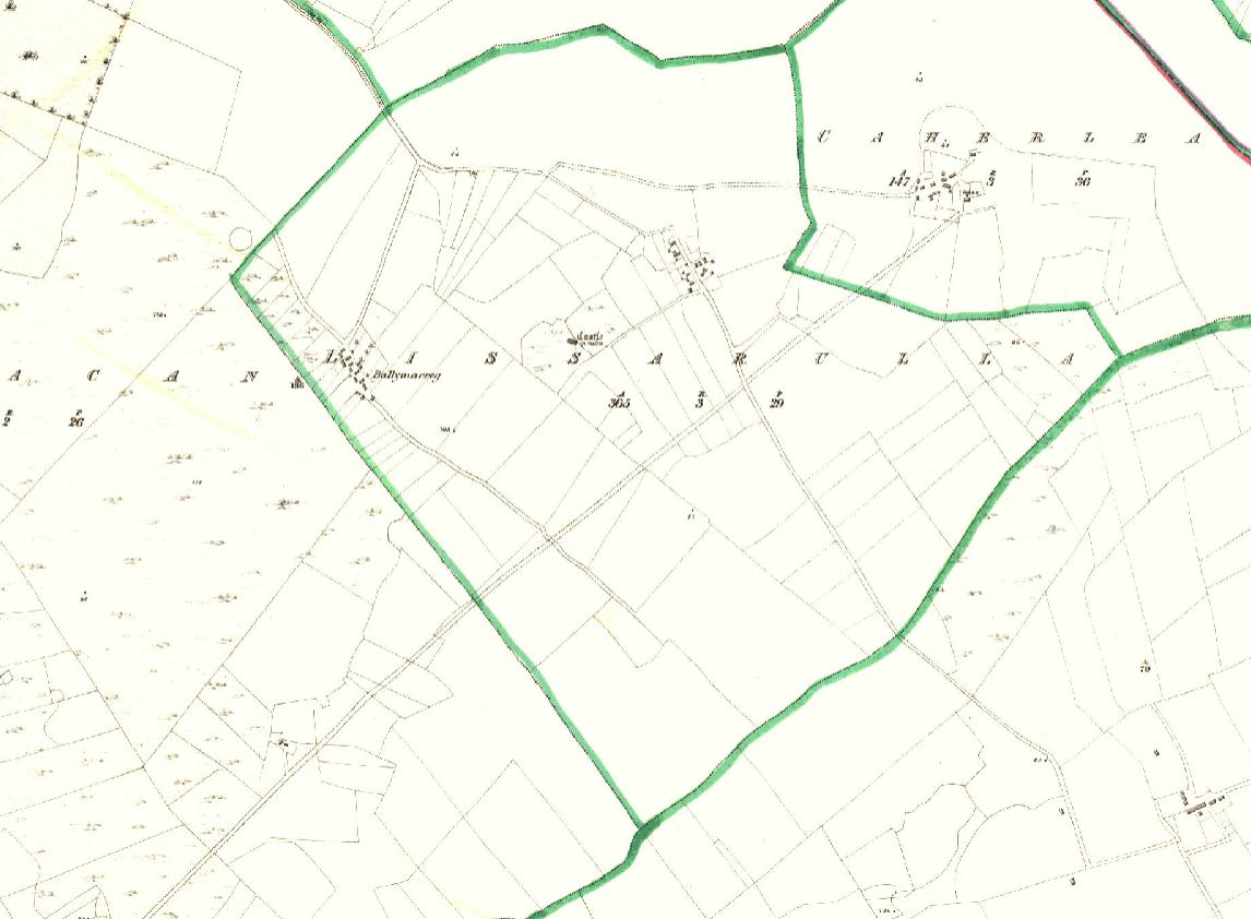
Lissarulla

![]()
![]()
![]()
Description
Lissarulla is the official name on the Ordnance Survey maps covering Ballymurphy and Ballinacreg but is not used by locals as often as the unofficial ones.
Name(s): Lissarulla townlands.ie/lissarulla
Gaeilge: Lios a Rula logainm.ie/lissarulla
Meaning(s): Ploughed Fort
Description: Most of the land is of good quality and is suitable for all types of farming, but also has some low-lying land, which is liable to flooding.
Situated: Lissarulla lies between Lydacan and Caherlea.
Sub-dominations: Ballymurphy and Ballinacregg
Boundaries-townland(s): Caherlea, Carnmore West, Gortatleva and Lydican.
Civil & Church of Ireland Parish: Claregalway – Claregalway Civil Parish (John Grenham)
Barony: Dunkellin – Connacht Baronies
District Electoral Division (DED): Carnmore – Map of Ireland
Poor Law Union (PLU): Galway (Poor Law Valuation) – Poor Law Unions (1851)
County: Galway – galway.ie
Diocese: The Diocese of Galway, Kilmacduagh and Kilfenora – Galway Rural
Province: Connacht(Connaught)
The Down Survey Map
(1650’s) No townland information available for Gortatleva, Claregalway. (The Maps for County Galway were destroyed in 1711)
Down Survey Landowners/lissarulla
O’Donovan’s field names book 1838
Families
: (Pre 1911)
Bodkin, Cavanagh, McDonagh, Qualter, Walsh, Williams, Hughes, O’Brien, Carr and Murphy
Landlord(s)
Andrew H Lynch
Records
(Claregalway Parish)
Tithe Applotments (c1827)
The names of occupiers and the size of their agricultural holdings, over one acre only, in each townland. To determine the amount that they should pay in tithes to the Church of Ireland. (titheapplotmentbooks.nationalarchives.ie)
Search Claregalway
Roman Catholic Parish Registers
- Baptism (Claregalway 1849-1881): The Catholic Church’s collection of the parish baptismal registry. (registers.nli.ie)
- Marriage (Claregalway 1849-1883): The Catholic Church’s collection of the parish matrimonial registry. (registers.nli.ie)
- Burial (Claregalway 1849-1876): The Catholic Church’s collection of the parish burial registry. (registers.nli.ie)
Griffith Valuation’s
Primary Valuation of Ireland
A survey involving a detailed valuation of every taxable holding of agricultural or built property on the island of Ireland. Completed between 1864-1865 . Date of Publication for Claregalway was 1855. (askaboutireland.ie)
Search Lissarulla
General Registry of Office (GRO) Records
- Civil Registery Birth: (1864-1915) The official State records of births in Ireland. (irishgenealogy.ie)
- Civil Registery Marriage: (1864-1940) The official State records of marriage in Ireland (irishgenealogy.ie)
- Civil Registery Death: (1864-1960) The official State records of death in Ireland (irishgenealogy.ie)
Census of Ireland (1821- 1911)
- 1821 vs 1831 (General Parish Population Only)
- 1831 (Summary of Returns for Claregalway Parish Only)
- 1841 (Summary of Returns for Parish Only)
- 1851 (Summary of Returns for Townlands Only)
- 1861 (Summary of Returns for Townlands Only)
- 1871 (Summary of Returns for Townlands Only)
- 1881 (Summary of Returns for Townlands Only)
- 1891 (Summary of Returns for Townlands Only)
- 1901 (Lissarulla)
- 1911 (Lissarulla)
Research
Index and Transcripts of memorials of deeds, conveyances and wills, 1708-1929
by Registry of Deeds, Dublin
familysearch.org/registryofdeeds/search/
Archaeological Survey of Ireland (ASI)
The Archaeological Survey of Ireland (ASI) is a unit of the National Monuments Service.
- Settlement deserted (medieval) – GA083-050002
archaeology.ie/historicenvironment/
More to Follow!
No Comments
Add a comment about this page