Lakeview


![]()
![]()
![]()
Description
Lakeview is the name of the townland where the present church, school and community centre lie. The old post office, which was owned by the Cahill family until 1927 was also in this townland. This was situated across the road from Dunleavey’s Bar, not far from the Nine Arches bridge. Local knowledge tells us of a church situated in the same area in the past but very little is known about it.
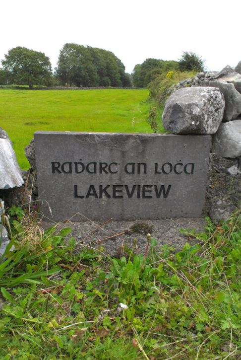
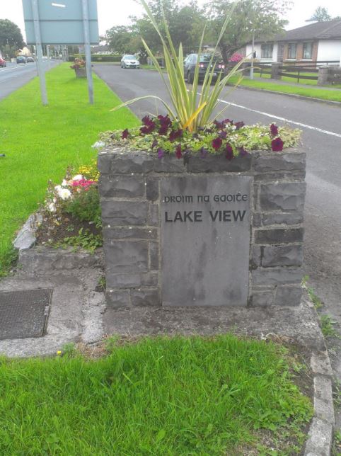
Name(s): Lakeview townlands.ie/lakeview
Gaeilge: Radharc na Locha logainm.ie/lakeview
Meaning(s): Radharc na Locha is a direct translation of Lakeview. Droim na Gaoithe’ (ridge of the wind) is the name on the Ordnance Survey maps.
Description: Most of the land is of good quality with some low-lying land near the river which floods in very wet weather when the Clare River floods the surrounding land, hence the name ‘Turloch Briege’ (false lake).
Situated: Townland East in the village of Claregalway.
Sub-dominations: Bóithrín de Burca
Boundaries-townland(s): Cahergowan or Summerfield, Claregalway, Cregboy, Kiniska and Lydican (Claregalway) Kiltroge (Lackagh).
Civil & Church of Ireland Parish: Claregalway – Claregalway Civil Parish (John Grenham)
Barony: Dunkellin – Connacht Baronies
District Electoral Division (DED): Carnmore – Map of Ireland
Poor Law Union (PLU): Galway (Poor Law Valuation) – Poor Law Unions (1851)
County: Galway – galway.ie
Diocese: The Diocese of Galway, Kilmacduagh and Kilfenora – Galway Rural
Province: Connacht(Connaught)
The Down Survey Map
(1650’s) No townland information available for Gortatleva, Claregalway. (The Maps for County Galway were destroyed in 1711)
Down Survey Landowners/lakeview
O’Donovan’s field names book 1838
Families
: (Pre 1911)
Hession, Galway, Commons, Duggan, Cordial, Morris, Lynch, Small, Murphy and Giles
Landlord(s)
James Galbraith
Records
(Claregalway Parish)
Tithe Applotments (c1827)
The names of occupiers and the size of their agricultural holdings, over one acre only, in each townland. To determine the amount that they should pay in tithes to the Church of Ireland. (titheapplotmentbooks.nationalarchives.ie)
Search Claregalway
Roman Catholic Parish Registers
- Baptism (Claregalway 1849-1881): The Catholic Church’s collection of the parish baptismal registry. (registers.nli.ie)
- Marriage (Claregalway 1849-1883): The Catholic Church’s collection of the parish matrimonial registry. (registers.nli.ie)
- Burial (Claregalway 1849-1876): The Catholic Church’s collection of the parish burial registry. (registers.nli.ie)
Griffith Valuation’s
Primary Valuation of Ireland
A survey involving a detailed valuation of every taxable holding of agricultural or built property on the island of Ireland. Completed between 1864-1865 . Date of Publication for Claregalway was 1855. (askaboutireland.ie)
Search Lakeview
General Registry of Office (GRO) Records
- Civil Registery Birth: (1864-1915) The official State records of births in Ireland. (irishgenealogy.ie)
- Civil Registery Marriage: (1864-1940) The official State records of marriage in Ireland (irishgenealogy.ie)
- Civil Registery Death: (1864-1960) The official State records of death in Ireland (irishgenealogy.ie)
Census of Ireland (1821- 1911)
- 1821 vs 1831 (General Parish Population Only)
- 1831 (Summary of Returns for Claregalway Parish Only)
- 1841 (Summary of Returns for Parish Only)
- 1851 (Summary of Returns for Townlands Only)
- 1861 (Summary of Returns for Townlands Only)
- 1871 (Summary of Returns for Townlands Only)
- 1881 (Summary of Returns for Townlands Only)
- 1891 (Summary of Returns for Townlands Only)
- 1901 (Lakeview)
- 1911 (Lakeview)
Research
Index and Transcripts of memorials of deeds, conveyances and wills, 1708-1929
by Registry of Deeds, Dublin
familysearch.org/registryofdeeds/search/
Archaeological Survey of Ireland (ASI)
The Archaeological Survey of Ireland (ASI) is a unit of the National Monuments Service.
No entries for Lakeview
archaeology.ie/historicenvironment/
More to Follow!
No Comments
Add a comment about this page