The minor placenames of the townlands of Carnmore, Carnmore East, and Carnmore West, in the parish of Claregalway, Co. Galway
Located at the southern end of the parish, the townlands of Carnmore, Carnmore East, and Carnmore West are peculiar, being split between two parishes and two baronies:
- Carnmore – Parish of Athenry, Barony of Clare
- Carnmore West – Parish of Claregalway, Barony of Dunkellin
- Carnmore East – Parish of Claregalway, Barony of Clare
In fact, the townland of Carnmore is in the parish of Athenry and should technically not be included in our survey. There was a shift in the boundary between Carnmore East and Carnmore West in the years between 1838 and 1895. The collective Carnmore townlands could almost be considered a district in their own right, with Carnmore having its own school (opened in 1885). Together the townlands cover an area of 2,444 acres with the townland boundary generally following the local topography and defining an area of high ground with the land gently dropping away on all sides.
Carnmore is distinctive in terms of topography, being generally higher in elevation than the rest of the parish. Thomas O’Connor, in a letter to John O’Donovan in 1838, noted the following about Carnmore and in particular the ruins of Cloch Maol Castle, situated in there:
‘There was a castle called Cloch Maol formerly in this parish. A ‘buttment’ of it is still to be seen, according to local information, in Carnmore land, where there was also a monument of stones similar in form to a fort, which probably was the feature that gave name to the land. The people did not, however, latterly call it Carn. It went commonly by the name of fort from its similarity in form to one, as has been already remarked. A small portion of this monument, is said to be still visible. I find it remarked in the Name book that Cloughmeel was once a convent. Does this appear from any authentic source?’
This is indeed an intriguing entry. No ecclesiastical settlement of any antiquity is known in Carnmore and it is unusual for a later castellated settlement to supplant an earlier ecclesiastical one. Nonetheless, we can see that the area around Cloch Maol was perhaps the focal point for settlement from at least the early medieval period onward with a fort (in fact multiple ringforts) and, later, a castle being situated there. The area around Cloch Maol also shows evidence of early field systems and house sites. Cloch Maol itself translates as ‘bald stone’, perhaps referring the thin soil cover and often-exposed bedrock.
At the time of the compilation of the Ordnance Survey Name Books in the 1830s the townlands are recorded as:
- Carnmore – ‘It is the property of Mr. Blake, containing 169½ statute acres, 1/3 rd. of which is cultivated, the remainder dry heathy pasture. It is bounded on North by the road from Galway to Athenry and at an angle near the centre of its West side is a spot called Cruckanashan?.
- Carnmore West – ‘It is the property of Mr. Blake, County of Mayo. All under cultivation with the exception of a few patches of rocky pasture. Near the townland centre stands the ruin of an old Castle, a portion of its North end is subject to Winter floods, and at its western extremity stands a Trigl. Station 136 feet above the level of the sea, near which is a village of houses’
- Carnmore East – ‘It is the property of Mr. Blake of County of Mayo. Half the townland is cultivated. The remainder heathy pasture. The road from Galway to Monivea forms its South boundary. Subject to winter floods. From a very large heap or pile of stones which was there from this heap most of the walls were built that bounds the townland.’
Our work in the townlands during 2021 identified 58 minor placenames and places of interest known locally. These placenames were collected from TJ Hynes, Roddy Kenny, Michael Fox, Malachy Hanly, Phil Clarke, William Flaherty, Fergus Hanley, Joe Lardner, Noel Grealish, John Carr, Declan Collins and Mary Walsh by Pat Coen and Seamus O’Connell.
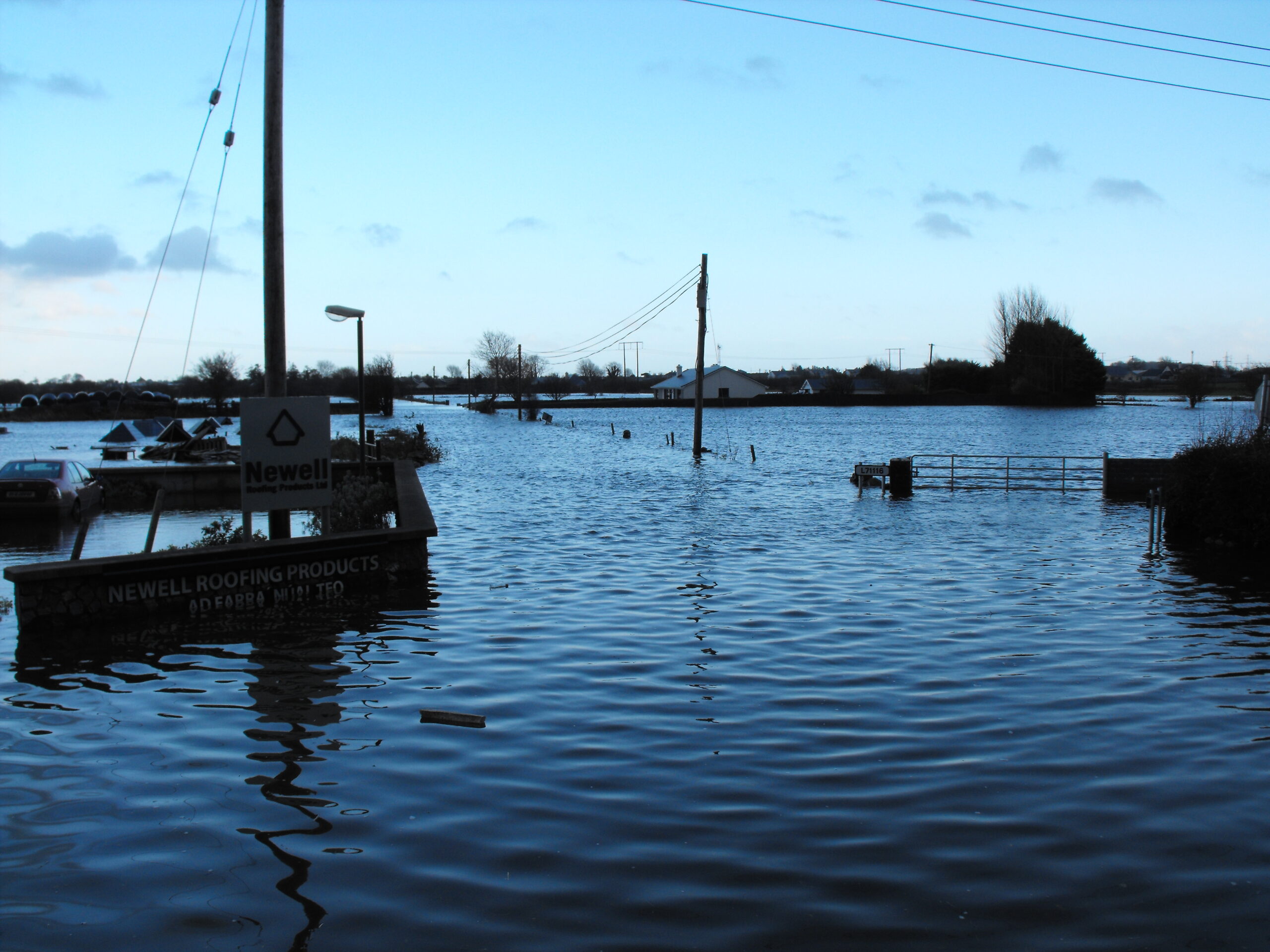
Carnmore Road Flooding during November 2009
This work is on-going. If you know of any other minor placenames in the parish of Claregalway that may be of interest, and you would like to contribute to our survey, please do get in touch.
| Map Reference | Townland | Name |
Notes |
| 76 | Carnmore West | An Balla Mór | The big wall |
| 77 | Carnmore West | An Cnocán | The Hill/Summit |
| 78 | Carnmore West | An Cúinne Cam | The winding bend |
| 79 | Carnmore West | An Seanbhaile | The old homestead |
| 80 | Carnmore West | An Tuairín | A little animal-enclosure/grassy plot. |
| 81 | Carnmore West | An Tuairín | A little animal-enclosure/grassy plot. |
| 82 | Carnmore West | Ballynew | Ballynew |
| 83 | Carnmore West | Bóthar Scathail | The shaded road |
| 84 | Carnmore West | Bulls Field | Bulls Field |
| 85 | Carnmore West | Caher Boreen | The laneway to the fort |
| 86 | Carnmore West | Caher Well | The fort well |
| 87 | Carnmore West | Clais Braon | The stinking/foul trench/ravine |
| 88 | Carnmore West | Cloch Mhaol | The bare rock |
| 89 | Carnmore West | Cnocán Mór | The big summit |
| 90 | Carnmore West | Creigín | The little rocky place |
| 91 | Carnmore West | Druileál | The drills (agricultural) |
| 92 | Carnmore West | Garraí Eamon | Eamon’s Garden |
| 93 | Carnmore West | Gort a’ phisa [pise] | Field of the peas |
| 94 | Carnmore West | Kings Field | Kings Field |
| 95 | Carnmore West | Lios/Rareagh Fort | The Fort- Named ‘Rareagh Fort’, this is a poorly preserved circular rath (diam. 45m) |
| 96 | Carnmore West | Lisín | A children’s burial – This is a recorded monument |
| 97 | Carnmore West | Mass Rock (Site of) | Mass Rock (Site of) |
| 98 | Carnmore West | Páirc Na Mhucaí | The pig’s field |
| 99 | Carnmore West | Páirc na Rásaí | The Race Field |
| 100 | Carnmore West | Páircín Shéamais | Seamus’ little field |
| 101 | Carnmore West | Park or Heath | Park or Heath |
| 102 | Carnmore West | Stiall Mhór | The big strip |
| 103 | Carnmore West | The Big Field | The Big Field |
| 104 | Carnmore West | The Cregg | The Cregg |
| 105 | Carnmore West | The Iron Gate Field | The Iron Gate Field |
| 106 | Carnmore West | The Rough Field | The Rough Field |
| 107 | Carnmore West | The tank field | The tank field |
| 108 | Carnmore West | Tobar Baile Nua | The homestead well |
| 109 | Carnmore West | Well (Sundial) | A well known locally as the Sundial Well |
| 110 | Carnmore West | White Páircín | The white little field |
| 111 | Carnmore West | Gortaleasa | Gortaleasa – this is likely derived from ‘Field of the Lios’ |
| 112 | Carnmore West | Cúinne Geal | The bright Corner/bend – understood to be in the vicinity of Galway airport |
| 113 | Carnmore West | Bóithrín Tobar Nua | Bóithrín Tobar Nua |
| 114 | Carnmore West | Tobar na gCaili | Possibly ‘The Hag’s Well’ – The well is not marked on any cartographic sources |
| 115 | Carnmore West | Silkes Well | Only marked on the Cassini 6-inch edition – a roadside well on the approach to Carnmore school |
| 116 | Carnmore West | Four Mile House | Four Mile House – Marked on Larkins 1819 Map of Galway. At what is today known as Carnmore Cross, Four Mile House is noted being 4 miles from Galway A pub is located here and noted in the Ordnance Survey Name Books in the 1830s. |
| 117 | Carnmore West | Thurloughheysal | Recorded on Larkins 1819 map of County Galway, as being at the southern end of Carnmore: Thurloughheysal. Probably derived from íseal, meaning low-lying |
| 118 | Carnmore West | Carnmore Village | Carnmore Village |
| 119 | Carnmore East | An Cnocán | The summit |
| 120 | Carnmore East | Carraig | A rock |
| 121 | Carnmore East | Clover Field | Clover Field |
| 122 | Carnmore East | Farm Mountain | Farm Mountain |
| 123 | Carnmore East | Móinín Above | The little bog above |
| 124 | Carnmore East | Móinín Below | The little bog below |
| 125 | Carnmore East | Páircín | The little field |
| 126 | Carnmore East | Small Mountain | Small Mountain |
| 127 | Carnmore East | The Three Gardens | The Three Gardens |
| 128 | Carnmore East | Lochán Buí | The yellow lake. An area prone to flooding at the northern end of the townland. Location is uncertain bur presumed from topographical description |
| 129 | Carnmore East | Sean Bhaile Beag | Old Village |
| 130 | Carnmore | Black Mountain | Black Mountain |
| 131 | Carnmore | Crocknashammer | The clover summit. A rock is marked at this location on the First Edition 6-inch Ordnance Survey Map |
| 132 | Carnmore | Gort na leaba | The Field of the bed. Sometimes the use of the word leaba can refer to a megalithic monument. There may be some confusion between this placename and Gortaleasa? |
| 133 | Carnmore | The Big Field | The Big Field |
No Comments
Add a comment about this page