The unrecorded minor placenames in the townlands of Peak, Mullaghruttery, Knockdoemore and Rooaunmore, Claregalway, Co. Galway
The townlands of Knockdoemore, Peak, Mullaghruttery and Rooaunmore are located north of Claregalway Village and at the northern boundary of the parish. The 11th century text Crichaireacht cinedach nduchasa Muintiri Murchada (MS 1319) tells us that the O’Innogs were the chiefs of Knockdoe – an area that would likely have included all of the townland Knockdoemore and the adjoining townlands of Knockdoebeg East and Knockdoebeg West. This was, in effect, the landscape of the Hill of Knockdoe and the adjoining lands to the south and west of it. The majority of this area today lies in the Parish of Lackagh.
Easily spotted in the remarkably flat landscape, the low Hill of Knockdoe is of course best known for the Battle of Knockdoe between Gerald FitzGerald, Earl of Kildare, the Lord Deputy of Ireland, and Ulick Fionn Burke, 6th Earl of Clanricarde, in the year 1504. But the hillside is also dotted with numerous ringforts and archaeological evidence for past settlement which stretches back to the Bronze Age. Given the hill’s prominence in the landscape, this is hardly surprising. At just 65 m OD, it still manages to be one of three significant peaks on the plains to the east of Lough Corrib, the others being Knockroe to the northeast and Knockmaa to the northwest.
The townland of Knockdoemore cover an area of approximately 817 acres. This part of the parish is notable as the area where three major routeways come together; the Galway-Tuam Road, the Galway-Roscommon Road, and prior to the construction of the Curragh Line in the 1860s, the route from Galway to Headford which was via Loughgeorge and Aucloggeen. It may even be, that the Hill of Knockdoe served as a natural signpost before any established roadways. This coming together of routeways may have made the location an attractive place for the travelling community to meet, and we find the placename ‘Tinker’s Lane’ here – the long-established though no longer used site of a travelling camp.
It may also be that this confluence of routeways influenced the choice of location for the later establishment of a forge here, with the traffic of horses travelling to Galway undoubtedly offering good custom to the forge, which is known to have been in existence at this spot since at least 1838, and under the continuous ownership of the Smith family since. This forge has been restored in recent years and is now adjacent to the Claregalway Museum.
Looking south and west from Knockdoemore, the adjacent townlands of Rooaunmore and Peak are perfectly flat and featureless – a fact that emphasises the orderly arrangement of the fine stone walls in the townlands. Laid out with little to obstruct their path, these walls of angular undifferentiated Visean Limestones are the epitome of the character of the landscape of Claregalway, and are often remarked upon. In the townland of Rooaunmore, the land divisions were sufficiently large that the flat fields were reputedly used for horse racing in the early part of the 20th century: perhaps related in some way to the races that are known to have taken place in the adjoining townland of Loughgeorge around the same time. To the west, the land rises ever so slightly into the townland of Mullaghruttery – a placename that is intriguingly interpreted as The Knights Hilltop by past scholars of An Brainse Logainmneacha.
- Knockdoemore (Cnoc Tua Mór – ‘the hill of the big territory’. The placename is often believed to be associated with the 1504 battle (hill of the axes), though it would appear to predate the battle by several centuries)
- Peak (Péic– a peak or high point)
- Mullaghruttery (Mullach Otraigh – The Knights Hilltop)
- Rooaunmore (An Ruán Mór – Possibly the big area of Redfern)
Our work in the townlands identified 25 minor placenames and places of interest known locally. These are marked on the map below, and included in tabulated format. These placenames were collected from Seamus O’Connell and Peter Greally.
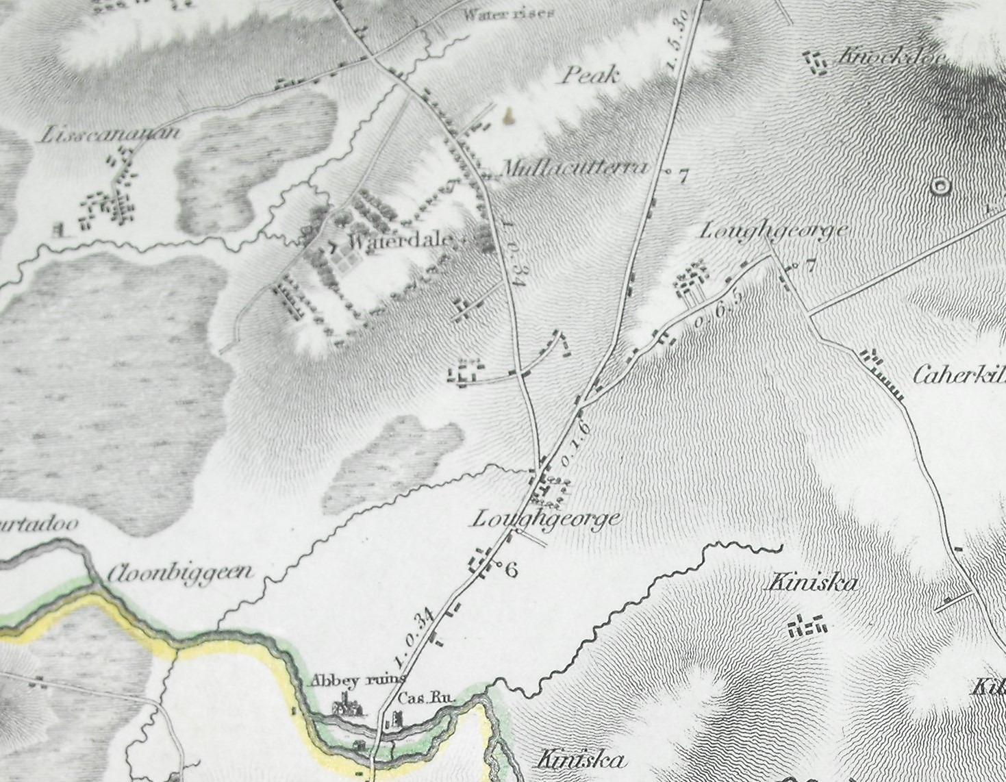
Larkin’s 1812 Map of Galway showing Loughgeorge and old route of the Roscommon Road via Tinkers Lane
| Map Reference | Townland | Name |
Notes |
| 368 | Peak | Fordes Bóithrín | Fordes Bóithrín |
| 369 | Peak | The Well Field | The Well Field |
| 370 | Peak | Duffy’s Field | Duffy’s Field |
| 371 | Rooaunmore | Clais | A trench/ravine |
| 372 | Rooaunmore | Keaney’s Field | Keaney’s Field |
| 373 | Rooaunmore | Keaney’s Garden | Keaney’s Garden |
| 374 | Rooaunmore | Smith’s House and Forge | Smith’s House and Forge. Marked on the First Edition 6-inch Ordnance Survey in 1838, and recorded as being occupied by Margaret Smith in Griffiths Valuation in the 1850s. It is a long-established forge that remained in the Smith family, and which is now adjacent to the Claregalway Museum |
| 375 | Knockdoemore | Baile Uí Chonaill | O’Connell’s place |
| 376 | Knockdoemore | Herds House | Herds House |
| 377 | Knockdoemore | Mass Path | A Mass Path crossing to Lackagh Church |
| 378 | Knockdoemore | Tinkers Lane | A laneway between the N17 and the Roscommon Road with a long-established tradition of the travelling community camping here. The southern portion of the lane once formed part of the Galway-Roscommon Road: The laneway is recorded in the school’s folklore collection: Bóithrín na dtinncéirí mar go mbíonn tinncéirí ina gcomhnuidhe ann go minic. |
| 379 | Mullaghruttery | Apple Garden | Apple Garden |
| 380 | Mullaghruttery | Coiléar [Cairéal] | The quarry |
| 381 | Mullaghruttery | Garraí Bán | The white garden |
| 382 | Mullaghruttery | Middle Field | Middle Field |
| 383 | Mullaghruttery | Páircín | The small field |
| 384 | Mullaghruttery | Road Field | Road Field |
| 385 | Mullaghruttery | Sean Pháirc | The old field |
| 386 | Mullaghruttery | Seven Acres | Seven Acres |
| 387 | Mullaghruttery | The Big Field | The Big Field |
| 388 | Mullaghruttery | The Closh Field | A field with a ravine of pronounced dip that was prone to flooding |
| 389 | Mullaghruttery | The Corner Field | The Corner Field |
| 390 | Mullaghruttery | The Hill Field | The Hill Field |
| 391 | Mullaghruttery | The Plum Field | The Plum Field |
No Comments
Add a comment about this page