Kiniska
Cinn Uisce
Claregalway Parish 750 History, 1999


Google Maps, Kiniska
![]()
![]()
![]()
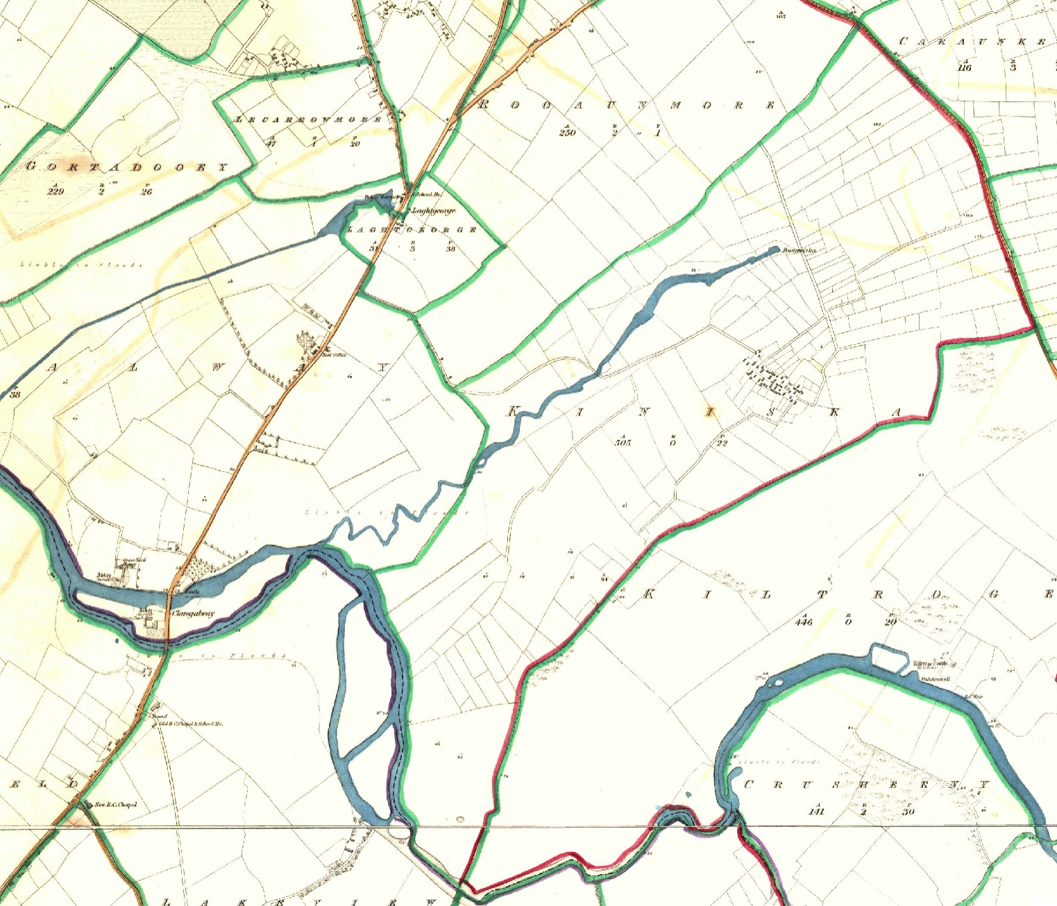
Description
Lord Clanmorris retained 18 acres for his own use for hunting. It was described as a ‘fox cover’ in the Griffith’s Valuation of 1855; that area may have been the wood that was on Pat Duggan’s land until about 1953 when it was cut down. The herdsman at that time was Patrick Nalty. There is a lisheen not far from Bun an Uisce and the last children were buried at the turn of the century and there is a souterrain or cave near the village.
Name(s): Kiniska townlands.ie/Kiniska
Gaeilge: Cinn Uisce logainm.ie/Kiniska
Meaning(s): The Water’s head or Rivers mouth
Description: The quality of the land is mainly good with some low-lying land beside Kiniska River, which rises, as the name would suggest, at Bun an Uisce and joins the Clare River about one mile away. .
Situated: Kiniska adjoins the Clare River and Kiltrogue.
Sub-dominations: Bun an Uisce, Carraun / Carán, Pollanrumpa and Tón an Cnoic
Boundaries-townland(s): Claregalway Kiltroge Lakeview and Rooaunmore (Claregalway) Cahernashilleeny, Caraunkeelwy and Knockdoemore (Lackagh).
Civil & Church of Ireland Parish: Claregalway – Claregalway Civil Parish (John Grenham)
Barony: Clare – Connacht Baronies
District Electoral Division (DED): Claregalway – Map of Ireland
Poor Law Union (PLU): Galway (Poor Law Valuation) – Poor Law Unions (1851)
County: Galway – galway.ie
Diocese: The Diocese of Galway, Kilmacduagh and Kilfenora – Galway Rural
Province: Connacht(Connaught)
The Down Survey Map
(1650’s)
Search Down Survey Landowners/Kiniska
O’Donovan’s field names book 1838
Search Kiniska
Families
: (Pre 1911)
Burke, Casserley, Commins, Connell, Kelly, Long, Nalty and Shaughnessy
Landlord(s)
Lord Clanmorris (Bingham Family)
Records
(Claregalway Parish)
Tithe Applotments (c1827)
The names of occupiers and the size of their agricultural holdings, over one acre only, in each townland. To determine the amount that they should pay in tithes to the Church of Ireland. (titheapplotmentbooks.nationalarchives.ie)
Search Claregalway
Roman Catholic Parish Registers
- Baptism (Claregalway 1849-1881): The Catholic Church’s collection of the parish baptismal registry. (registers.nli.ie)
- Marriage (Claregalway 1849-1883): The Catholic Church’s collection of the parish matrimonial registry. (registers.nli.ie)
- Burial (Claregalway 1849-1876): The Catholic Church’s collection of the parish burial registry. (registers.nli.ie)
Griffith Valuation’s
Primary Valuation of Ireland
A survey involving a detailed valuation of every taxable holding of agricultural or built property on the island of Ireland. Completed between 1864-1865 . Date of Publication for Claregalway was 1855. (askaboutireland.ie)
Search Kiniska
General Registry of Office (GRO) Records
- Civil Registery Birth: (1864-1915) The official State records of births in Ireland. (irishgenealogy.ie)
- Civil Registery Marriage: (1864-1940) The official State records of marriage in Ireland (irishgenealogy.ie)
- Civil Registery Death: (1864-1960) The official State records of death in Ireland (irishgenealogy.ie)
Census of Ireland (1821- 1911)
- 1821 vs 1831 (General Parish Population Only)
- 1831 (Summary of Returns for Claregalway Parish Only)
- 1841 (Summary of Returns for Parish Only)
- 1851 (Summary of Returns for Townlands Only)
- 1861 (Summary of Returns for Townlands Only)
- 1871 (Summary of Returns for Townlands Only)
- 1881 (Summary of Returns for Townlands Only)
- 1891 (Summary of Returns for Townlands Only)
- 1901 (Kiniska)
- 1911 (Kiniska)
Research
Index and Transcripts of memorials of deeds, conveyances and wills, 1708-1929
by Registry of Deeds, Dublin
familysearch.org/registryofdeeds/search/
Archaeological Survey of Ireland (ASI)
The Archaeological Survey of Ireland (ASI) is a unit of the National Monuments Service.
- Souterrain – GA070-115
- Enclosure – GA070-113
archaeology.ie/historicenvironment/
More to Follow!


No Comments
Add a comment about this page